
Page 41 - ELITE PLUS MAGAZINE VOL9
P. 41
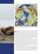
Map of the Arctic Circle showing the location of Svalbard Archipelago (red circle)Svalbard Archipelago, a Norwegian territory, is the world’s most northern group of islands in the Arctic Ocean occupying the total area of 61,022 square km. It is located approximately midway between continental Norway and the North Pole. The archipelago is a part of the Arctic Circle which comprises 8 countries on the rim of the Arctic Ocean, namely Norway, Sweden, Finland, Russia, USA (Alaska), Canada, Denmark (Greenland), and Iceland. The capital of the archipelago is Longyearbyen, a former mining settlement and now a polar research center and the booming tourist destination to explore the archipelago by cruise ships, snow mobiles, and trekking.My team comprising myself, my co-host, and two cameramen of the Thai TV documentary program “Beyond the Blue Horizon” embarked on a long flight from Bangkok to Oslo, the capital of Norway. After two days of rest and preparation for our adventure in the Arctic Circle, we flew on a three-hour domestic flight from Oslo to Longyearbyen to board the M/V Quest on the eleven-day cruise around the Svalbard Archipelago. It was in August, the most summer month in the archipelago, with the temperature of 0-5 degree Celsius in contrast to -50 degree Celsius in winter.M/V Quest, a small cruise ship carrying 47 passengers, departed Longyear- byen cruising along the western side of the main island of Spitsbergen heading south before crossing to the eastern side heading north. During the first two days, the ship passed several large glaciers and stopped at a few beautiful fjords allowing the passengers to explore the fjords and glaciers at close range on theElite+ 39
